"Clear Skies on Weather Apps, but Lightning on the Ridge?": Smartwatch '3hPa Drop' Storm Alert & Zero-Error Altimeter Calibration
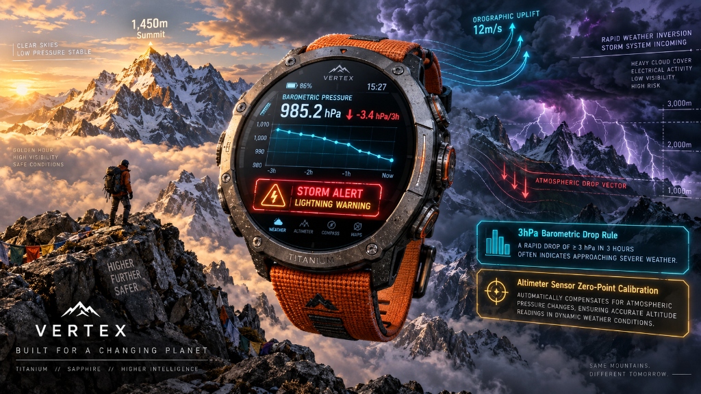
- 1Analyzing meteorological blind spots where lowland weather forecasts fail to predict high-altitude orographic uplift storms and ridge lightning strikes.
- 2The sensor physics behind Garmin, Apple Watch Ultra, and Galaxy Watch '3hPa / 3hr Drop (Storm Alert)' algorithms for early atmospheric cold front detection.
- 3Step-by-step 3-stage altimeter calibration protocol using trailhead markers and summit geodetic triangulation points to eliminate 100m+ GPS errors.
1. [Atmospheric Physics] Why Lowland Weather Apps Fail on High Alpine Ridges
- The Danger of Orographic Uplift: While valley weather stations report clear skies, warm moisture forced up steep mountain faces at 10-15m/s hits subzero upper air layers, forming massive cumulonimbus clouds in minutes. This triggers severe local squalls and dry lightning unpredicted by city apps.
- 2-Hour Lead Time of Barometric Trends: 1.5 to 2 hours before a storm strikes, rapid updrafts cause a sharp local atmospheric pressure drop. When your smartwatch barometer dips sharply, that is your golden window to abandon exposed rocky ridges for lower terrain.
- Storm Alert Sensor Algorithm: When ambient barometric pressure drops by ≥3.0 hPa (or 4.0 hPa) within 3 hours during rest or minimal elevation gain, the onboard sensor detects an incoming cold front and fires emergency haptic vibrations.
2. [Comparison Matrix] Smartwatch Barometer Pressure Graph Interpretation Matrix
| Pressure Trend Graph | Pressure Change Rate (3-Hour) | Meteorological Significance | Tactical Alpine Action |
|---|---|---|---|
| Steep Drop (📉 Plunge) | ≤ -3.0 hPa rapid plunge | Rapid cold front arrival; 95% probability of severe squall and lightning | Immediate Evacuation: Leave exposed ridgelines and steel cables; descend to sheltered valleys |
| Gradual Decline (↘️ Steady Drop) | -1.0 to -2.0 hPa | Low pressure approaching; dense fog and drizzle within 4-6 hours | Deploy hardshell rain jackets; shorten route to finish before sundown |
| Horizontal Line (➡️ Flat) | 0.0 to ±0.5 hPa | High pressure stability; perfect cloud sea (inversion) & clear panoramic views | Maintain planned thru-hike itinerary; optimal summit sightseeing |
| Steep Spike (📈 Rapid Surge) | ≥ +2.5 hPa rapid rise | Storm clearing followed by strong northwest winds and temperature drop | Equip windbreakers and thermal gloves immediately to counter severe wind chill |
3. [Setup Protocol] 3-Step Zero-Error Altimeter Calibration Protocol
Initial Trailhead Elevation Benchmark Calibration
Before departing, open [Sensors] ➔ [Altimeter] and manually input the exact elevation printed on the trailhead marker (e.g., 185m) instead of relying solely on GPS.
Enable Storm Alert Threshold (3.0 hPa / 3 hr)
Configure the barometer storm alarm to trigger at a 3.0 hPa drop per 3 hours, ensuring early haptic alerts when barometric pressure collapses.
Secondary Summit Triangulation Point Recalibration
As weather worsens and barometric pressure drops, altimeters overestimate elevation by 50-100m. Recalibrate at summit geodetic survey monuments to maintain 100% topographic map accuracy.
Common Rookie Mistakes & Proven Solutions
Smart Buyer's Guide: Emergency Safety & Essential Gear
- •❌ Relying solely on smartphone flashlight (drains battery and occupies hands)
- •❌ Pea-whistles with moving balls (freezes or jams with moisture during emergencies)
Essential safety setup for every day hiker
Sunrise/sunset chasers and all-season mountain trekkers
- ✓🔍 Headlamp with verified ANSI-FL1 lumen and runtime ratings
- ✓🔍 Pealess high-decibel whistle operable in wet/freezing conditions
- ✓🔍 Tear-resistant aluminum emergency thermal blanket (sub-50g)
Essential Hiking & Trail Glossary
The forced ascent of warm, humid air up mountain slopes, causing adiabatic cooling and rapid formation of severe storm clouds and lightning.
A smartwatch sensor safety feature that detects sudden barometric pressure drops (≥3hPa in 3h) to warn hikers of incoming severe weather.
The procedure of synchronizing a barometric altimeter to a known physical elevation benchmark to eliminate weather-induced drift.
Interactive Trail Safety Checklist
Tap each item before departing to verify readiness.
Generational Hiking Guide Series
Kids Trail Gamification & Scavenger Hunt
3 rules to turn early whining into joyful nature exploration
Couples Hiking Date & 10-Min Myth Guide
Pacing strategies, secret comfort gear, and scenic date peaks
4050 Spine Decompression & Fat Burn
Protecting lumbar discs while maximizing visceral fat loss
Hiking with Elderly Parents & Medical Kit
Barrier-free boardwalks, anti-shock poles, and medical safety